Show Geolocation
The Show Geolocation action opens the map application of the mobile device and displays the specified information. You can specify one of the following sub actions (see screenshot below):
•Show geolocation: The location on the map of the coordinates that you specify
•Show route from current location: The route on the map from the current location to a specified location
•Show route between locations: The map route on the map between two specified locations
All locations in these options are given by their geolocation coordinates.
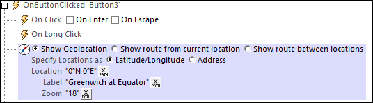
Show geolocation
The Show Geolocation action opens the map application of the mobile device, and places a pin and label at the specified geolocation.
The Show Geolocation action has the following settings:
•Specify Location as: Whether the entry of the Location setting (next setting) is a latitude/longitude coordinate or an address. The screenshot above shows that the latitude/longitude option has been selected.
•Location: The geolocation to be shown in the map. If a latitude/longitude coordinate is indicated in the previous Specify Location As setting, then the coordinates of the location must be entered as an XPath expression (as shown in the screenshot above). The generated string must have one of the lexical formats described in the Geolocation input string formats section below. If the Address option is selected, then the Location entry could be something like: "Rudolfsplatz 13a, 1010 Vienna".
•Label: The text of the label that is attached to the geolocation shown in the map. The text is entered as an XPath expression that generates an xs:string.
•Zoom: The zoom factor of the map when it is opened in the map application.
Show route from current location
The Show route from current location action opens the map application of the mobile device, and shows the route from the current location to the specified geolocation.
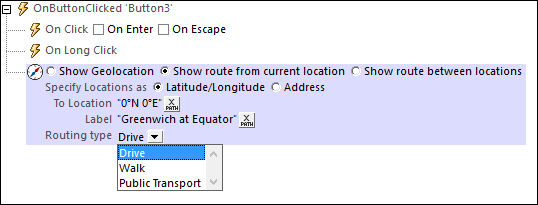
The Show route from current location action has the following settings:
•Specify Location as: Whether the entry of the Location setting (next setting) is a latitude/longitude coordinate or an address. The screenshot above shows that the latitude/longitude option has been selected.
•To Location: The destination location to be shown in the map. If a latitude/longitude coordinate is indicated in the previous Specify Location As setting, then the coordinates of the location must be entered as an XPath expression (as shown in the screenshot above). The generated string must have one of the lexical formats described in the Geolocation input string formats section below. If the Address option is selected, then the Location entry could be something like: "Rudolfsplatz 13a, 1010 Vienna".
•Label: The text of the label that is attached to the destination location shown in the map. The text is entered as an XPath expression that generates an xs:string.
•Routing type: Select the type of transport that will be used to travel the route: (i) Drive (private transport), (ii) Walk, (iii) Public Transport.
Show route between locations
The Show route between locations action opens the map application of the mobile device, and shows the route between the two specified geolocations.
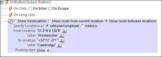
The Show route between locations action has the following settings:
•Specify Location as: Whether the entry of the Location settings are latitude/longitude coordinates or addresses. The screenshot above shows that the latitude/longitude option has been selected.
•From/To Location: The start and destination locations, respectively, to be shown in the map. The coordinates of the locations are entered as XPath expressions. If latitude/longitude coordinates are indicated in the previous Specify Location As setting, then the coordinates of the locations must be entered as XPath expressions (as shown in the screenshot above). The generated strings must have one of the lexical formats described in the Geolocation input string formats section below. If the Address option is selected, then the Location entries could be something like: "Rudolfsplatz 13a, 1010 Vienna".
•Label: The text of the label that is attached to the start and destination locations, respectively. Each text is entered as an XPath expression that generates an xs:string.
•Routing type: Select the type of transport that will be used to travel the route: (i) Drive (private transport), (ii) Walk, (iii) Public Transport.

The geolocation input string must contain latitude and longitude (in that order) separated by whitespace. Each can be in any of the following formats. Combinations are allowed. So latitude can be in one format and longitude can be in another. Latitude values range from +90 to -90 (N to S). Longitude values range from +180 to -180 (E to W).
Note: If single quotes or double quotes are used to delimit the input string argument, this will create a mismatch with the single quotes or double quotes that are used, respectively, to indicate minute-values and second-values. In such cases, the quotes that are used for indicating minute-values and second-values must be escaped by doubling them. In the examples in this section, quotes used to delimit the input string are highlighted in yellow (") while unit indicators that are escaped are highlighted in blue ("").
•Degrees, minutes, decimal seconds, with suffixed orientation (N/S, E/W) Example: 33°55'11.11"N 22°44'55.25"W
•Degrees, minutes, decimal seconds, with prefixed sign (+/-); the plus sign for (N/E) is optional Example: 33°55'11.11" -22°44'55.25"
•Degrees, decimal minutes, with suffixed orientation (N/S, E/W) Example: 33°55.55'N 22°44.44'W
•Degrees, decimal minutes, with prefixed sign (+/-); the plus sign for (N/E) is optional Example: +33°55.55' -22°44.44'
•Decimal degrees, with suffixed orientation (N/S, E/W) Example: 33.33N 22.22W
•Decimal degrees, with prefixed sign (+/-); the plus sign for (N/S E/W) is optional Example: 33.33 -22.22
Examples of format-combinations:33.33N -22°44'55.25" 33.33 22°44'55.25"W 33.33 22.45 |
For information about specifying geolocation data for designer and server simulations, see the section Geolocation Settings.
MobileTogether extension functions
MobileTogether provides a range of XPath extension functions that have been specifically created for use in MobileTogether designs. Some functions can be particularly useful with specific actions. For example, mt-available-languages() returns the languages in which the solution is available and could, for example, be used with the Message Box action. If a function is especially relevant to this action, it is listed below. For a full list of extension functions and their descriptions, see the topic MobileTogether Extension Functions.
mt-geo-map-marker()
mt-geolocation-started()